Transformative up-to-date flood data insights for South Oxford

Raising awareness and providing information with relevant data insights from national and local telemetry stations.

2025 - Present
  • UX
  • UI
  • Kirby CMS
  • GIS
  • ApexCharts
  • Web Design
  • Web Development

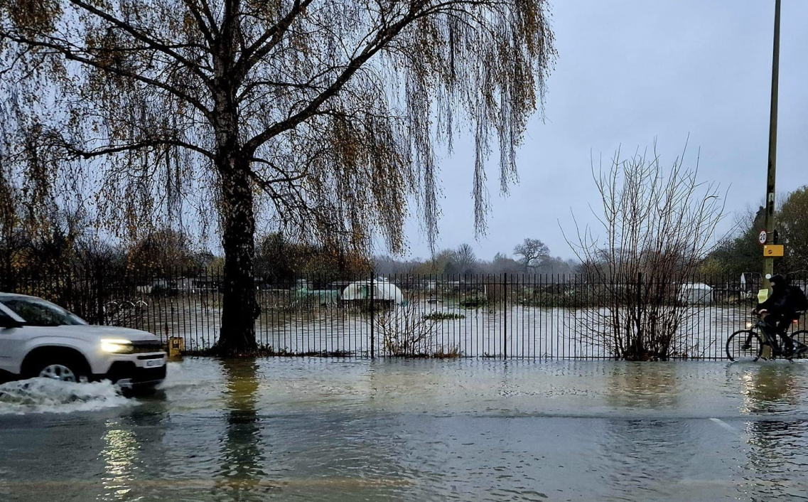
“Every flood is different...”

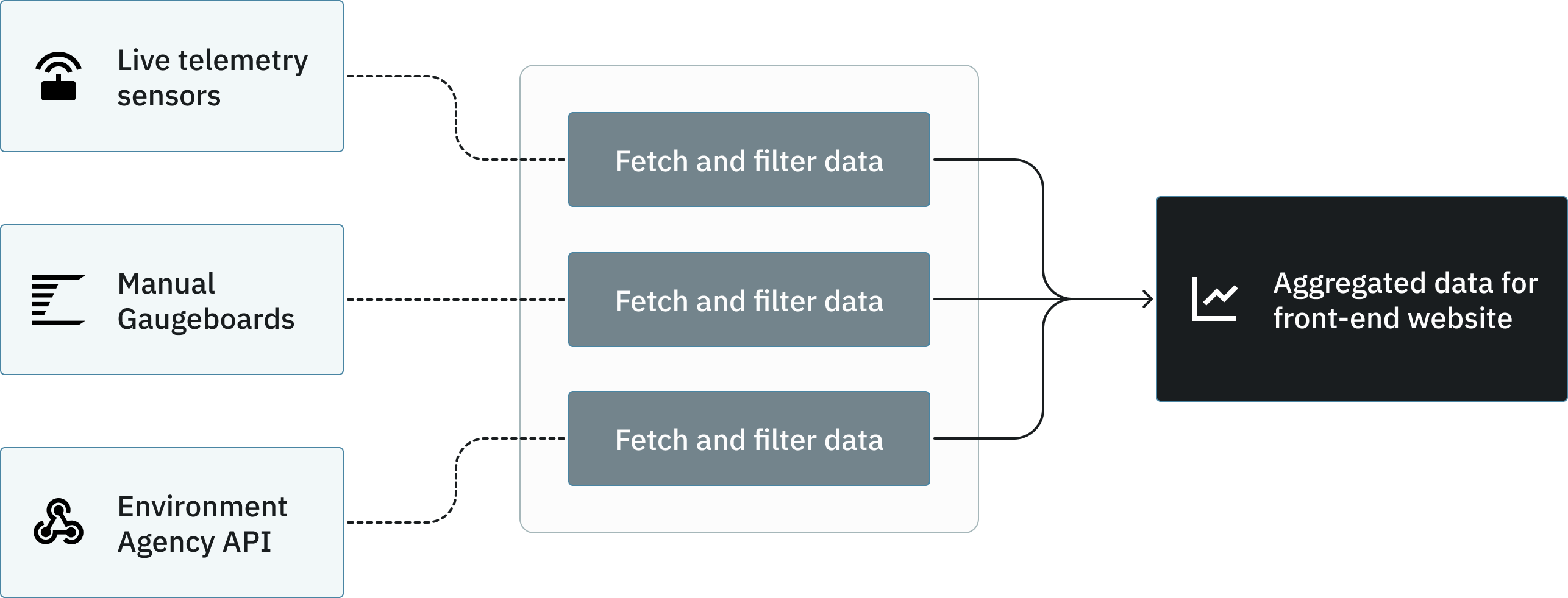
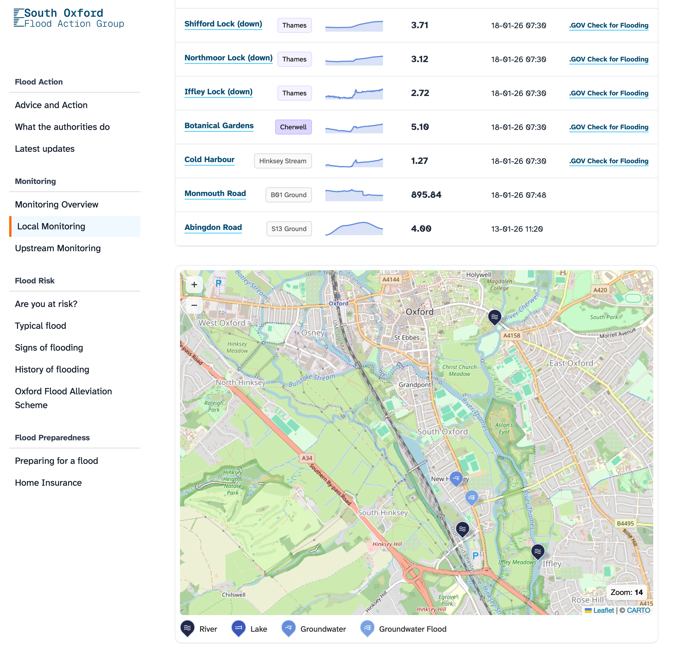
South Oxford Flood Action Group (SOFLAG) is a community group in partnership with local and national authorities, to provide data insights and information about flood preparedness and action at a local level, where wider area and national information cannot provide the detail needed to empower local communities.

southoxfordfloodaction.uk

Flood. Water flows from Cowmead allotments onto Abingdon Road

Filter and present multiple live data sources for a contextual narrative

Combining upstream and local data readings backed with local knowledge and historical data means residents have more relevant and powerful information to prepare and act.

  • Proving local telemetry sensor data values and reliability for groundwater readings
  • Manual gauge board readings from groundwater and rivers
  • Import live Environment Agency data
SOFLAG data model for fetch of data
Screenshot of 4 EA Monitoring stations, data with sparklines
Aggregated data: Sparklines have proved to be a valuable way to present multiple readings to see the bigger picture at a glance. Here we are showing a handful of upstream river level monitoring station live feeds.

Design and content structure for purpose

This project needed to be more than a collection of embedded dashboards of impenetrable technical data without context, with a unified UI that adds trust and aids ease-of-use. This was an end-to-end process starting with research and validation, through prototyping, design and development roadmap.

The aim was to build the most obvious and easy-to-understand reference website that has everything local residents are looking for:

  • Assess risk; How can I be prepared?
  • Prepare for flooding; What can I do for tomorrow?
  • Flood Action; What do I need do today?

Screenshot of the Signs of Flooding page
Signposting content in a clear readable format across all screen sizes was a key requirement highligted in the initial reseach stage.
Beyond numbers; Adding a map layer futher adds understanding by placing all the sensors in a real-world context.

Recognised and measurable impact for flood forecasting

Resources for community groups are powerful tools, and this is widely recognised. The SOFLAG site is aggregating and presenting accessible data so that it can be understood by members of the community who only engage when they need to, but will allow more detailed analysis.

SOFLAG will continue to build a network of live telemetry sensors, so that groundwater levels in particular can be presented in context alongside river levels to give more nuance around a complex picture. It's a great demonstration of what can be done with AI tools, Data APIs and Open Source libraries.

Cover - Journal of Flood Risk Management: Volume 18, Issue 4
Involving communities in flood early warning systems (FEWS) is increasingly recognised as an essential component of flood resilience. FEWS is considered to be integrated systems of flood forecasting and warnings, impact assessment, communication and preparedness which enable stakeholders to take appropriate actions to reduce the impacts of flooding. In the United Kingdom, voluntary, community-based flood groups can play an important role in local flood resilience, adding value to the work of Flood Risk Management Agencies including the Environment Agency, Local Authorities and Water Companies. Exploring the Use of Flood Early Warning Systems by Communities in England